This page outlines the results of a photographic survey of the A377 between Crediton and Exeter.
As a result of discussions with Sustrans it was agreed to explore the feasibility of constructing a shared use path alongside the main road.
In some locations the road has a very wide verge which, in principle, could accommodate a two-way shared use path. In other places the road is bounded by hedges or walls and there is no existing footpath nor room to accommodate one.
The study subjectively divided sections of the route into eleven distinct 'difficulty categories' and illustrative photos were taken in each section. Detailed results are described in this document
The output is also available in simplified form on a map.
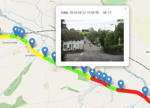
The above map reduces the original eleven 'difficulty categories' to just three :-
- red = very difficult or dangerous
- yellow - moderately difficult or impractical
- green = distinctly possible
The blue markers indicate the locations where the photos were taken, and clicking on a marker causes a pop-up to appear - showing a small thumbnail image.
Clicking on this thumbnail takes you to a gallery of all the photos, and clicking on any image in the gallery returns you to the map.
| Colour | Category | Distance (km) |
| red | very difficult | 1.6 |
| yellow | moderately difficult | 1.5 |
| green | distinctly possible | 5.7 |
| total | 8.8 |